Day 41 — Friday 10 June 2011
Louviers – Pont Audemer / Toutainville
| Route Details | ||
|---|---|---|
| Riding Distance | 38.23 ml | 61.52 km |
| Uphill Distance | 2.66 ml | 4.29 km |
| Downhill Distance | 8.54 ml | 13.74 km |
| Max Altitude | 541 ft | 165 m |
| Altitude Gain | 200 ft | 61 m |
| Altitude Loss | 538 ft | 164 m |
At the point when I was planning the trip I had thought it would be interesting to follow the Seine along its winding course to the sea, but I later changed that in favour of a straight course from Louviers due west to the valley of the Risle and then to follow that to the municipal campsite at Pont-Audemer for the night. At was quite straight forward navigating along the D81 to La Haye-du-Theil, then the D26 dropping steeply down to Le Buhot and finally the D29 that crosses the Risle at Pont Authou and follows it all the way to Pont-Audemer.
I set off wearing my fleece in a mere 10°C. Initially the route crossed high, exposed unbordered fields dotted with small villages and towns before dropping into the valley of the Risle where hedges and woodland enclosed the lanes interspersed with cattle pastures. I found lunch in a small restaurant and as I sat down I heard other diners asking for cordon bleu, so thinking this was obviously the speciality of the place I ordered it too. For several days restaurants had offered a self service buffet as a starter, and after that my main meal arrived. I would normally associate spam fritter and chips with haute cuisine but that’s what I got.
I came out feeling well fed up into light rain so put on my wet weather kit, including my Rainlegs that I had not worn since Chartres. The temperature dropped from 15°C back down to 10°C and I shivered down into the Risle valley. Eventually the D29 joined the D675, a dual carriageway forming a bypass round Pont-Audemer. I stopped at a large Carrefour supermarket for bananas, bread and cheese and as I was coming out an English couple approached interested in my bicycle. They thought I looked typically English and using Carradice panniers confirmed it for them. In any case they said you can’t hide your Englishness, it just sticks out like a sore thumb.
It had stopped raining and warmed up a bit so I packed away my rain kit and cycled back onto the dual carriageway. I hate navigating major roads on a bicycle, but as it turned out I came across a Centre Ville sign that got me off the bypass. In the centre I found a campsite sign for Camping Risle Seine Les Etangs that led down a back street along the River Risle that at one time would have been a series of quays for barges. I could see flag poles in the distance bearing colourful international flags and guessed that must be the site. It was basking in warm sunshine and unusually I was asked to use a specific pitch. Things must have been getting busier but even so only one of the two services blocks was functioning. I showered, washed my clothes and draped them over the closely manicured hedges round my plot.
I had got too used to empty campsites and plugged my Bryton GPS into a wash cubicle in the services block as my solar panel hadn’t had enough sunshine to charge up. When I went back a couple of hours later the Bryton had gone. I thought of notifying the police but the only point of that would have been to get a crime number to quote to my insurers, and they wouldn’t uphold my claim as the Bryton had been left unsecured in a public place, so I didn’t bother. I was pretty annoyed with myself.

Route – Day 41
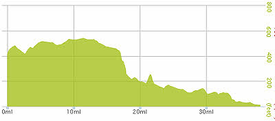
Gradient – Day 41
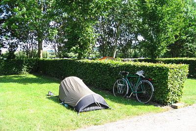
Camping Risle Seine Les Etangs (17:17)