Day 16 — Friday 13 May 2011
Avila – Segovia
| Actual Route Details | ||
|---|---|---|
| Riding Distance | 38.81 ml | 62.45 km |
| Uphill Distance | 15.84 ml | 25.50 km |
| Downhill Distance | 18.29 ml | 29.44 km |
| Max Altitude | 4007 ft | 1221 m |
| Altitude Gain | 2405 ft | 733 m |
| Altitude Loss | 2651 ft | 808 m |
| Planned Route Details | ||
|---|---|---|
| Riding Distance | 48.45 ml | 77.97 km |
| Uphill Distance | 22.14 ml | 35.63 km |
| Downhill Distance | 22.76 ml | 36.63 km |
| Max Altitude | 4277 ft | 1304 m |
| Altitude Gain | 2884 ft | 879 m |
| Altitude Loss | 3051 ft | 930 m |
Getting out of Avila was interesting. It is not possible to show my actual route from the city centre on the map as Google doesn’t recognise the route I took as a road. Heading out of Avila on the N-110a was straightforward up to the last roundabout before the autovia, but then it went straight up to the autovia and there was no indication of where non-motorway traffic should go. On my right was what looked like the old road, running parallel to the autovia slip road through scrub and trees and servicing small industrial sites, so I followed it. It dipped down to the right and then hooked round left, underneath the autovia and up the other side to another roundabout on the old N-110. Just before the lane rejoined the main road there was an entrance to a bar’s car park so I stopped for a second breakfast.
I should have followed the planned route shown below and in hindsight this would have been the better option. The main road (N-110) looked shorter and straighter so that’s where I went, but it was very busy and at one point I was sucked into the slip stream of a lorry that didn’t leave enough room and I nearly came off. As I got closer to Segovia I had had enough and left the main road at Madrona for the much quieter SG-724 in the hope of finding somewhere for lunch. The road twists down and then steadily up through an attractive gorge with low cliffs and scrub vegetation. I stopped at a road side bar-restaurant at Hontoria and ate very well on paella followed by pork cutlets in a sort of goat’s milk batter.
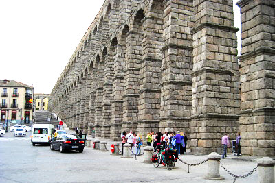
I rode into the centre of Segovia following signs for the Centro Historico. I stopped in my tracks as I came round a corner of a wide pedestrianised cobble-stone roadway leading down to the central square and saw the Roman aqueduct. I realised I had passed its beginnings as a low wall on my left and had not recognised it. From that inauspicious start it had stretched right across the deep valley to the other side, and is the final stage of an irrigation system bringing water all the way from the Riofrio 14km away. Apparently it is a dry stone construction and from the bottom of the valley is 28m tall. In my diary I guessed its height as 30m and visible length about 400m, but I understand it is 1200m long from its actual start to finish.
The tourist information office is in the square to one side of the aqueduct and they were able to give me a city map showing Camping el Aqueducto about a kilometre to the East, so after taking photographs off I went. The camp site was the only one open so early in the season but was about half full of caravans and campervans from all over the place; lots of Spanish of course, but quite a few from Holland and three or four from England. From its end I could see and hear the N-110 that at this point forms part of the city ring road but from my tent I was shielded by trees on a raised grassy platform that cars couldn’t get onto and so appeared to be reserved for tents. Louder than the traffic was the chirping of cicadas (if that is what they do) and birds. There was a handy picnic bench on my platform and I sat in the warm evening sun enjoying supper of bread and cheese, writing my diary and sending a text message to Liz.
Everything on this campsite worked, the water was immediately hot from both showers and taps, there were separate clothes washing sinks and the washbasins all had plugs – now that was a novelty. The downside was that the campsite bar was not open nor was the shop, but hey! you can’t have everything.

Actual Route – Day 16
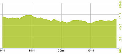
Actual Gradient – Day 16

Planned Route – Day 16
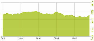
Planned Gradient – Day 16
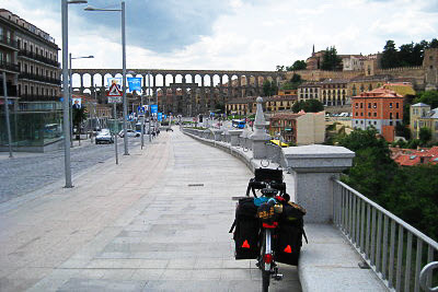
Segovia, the Roman Aquaduct (16:13)
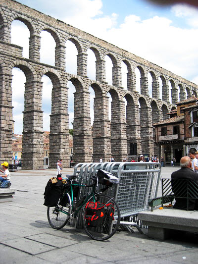
Segovia, the Roman Aquaduct (16:24)
Segovia, the Roman Aquaduct (16:29)
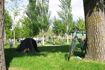
Camping El Aquaducto (17:39)

Way under the A-51 (Google)