Day 31 — Monday 30 May 2011
Atur – St Mathieu
| Route Details | ||
|---|---|---|
| Riding Distance | 57.33 ml | 92.26 km |
| Uphill Distance | 23.64 ml | 38.04 km |
| Downhill Distance | 22.28 ml | 35.85 km |
| Max Altitude | 1144 ft | 349 m |
| Altitude Gain | 2283 ft | 696 m |
| Altitude Loss | 1962 ft | 598 m |
I didn’t want to push my luck at the campsite so I was up at seven o’clock. By now my morning routine was on autopilot: personal wash (or shower when available, but not this morning); first breakfast of bread and cheese or salami and as much water as I could drink, at least a litre; toilet and teeth (sorry about the detail but these things are important); pack everything into its allotted stuff sack; strike the tent and pack it after a good shaking to get the dew off; slot all the stuff sacks, sleeping bag, tent, sleeping mat into relevant panniers; fit panniers onto the bicycle; walk round the site to check I’d not left anything behind and ride off into the morning sunshine (well, mostly). I was away by eight; pretty good that day although it usually took an hour and a half.
I rode back up the small lanes into Atur and found the D2 to Perigueux. I spotted the extraordinary domes of the cathedral down a side road that opened out on my right, but carried on along the main road to a bridge over the River Isle. There was the cathedral on the other side of the river, so I wheeled the bicycle down a footpath by the side of the river and took a photograph.
The next task was to get out of Perigeuex on the D3 to Agonac: not easy! I could see that I had to get to the north west corner of the city and turn right under a railway bridge after which a left turn would get me onto the D3. All I had to do was get the the north west of the city. It took a couple of back tracks and an enquiry at a newsagent’s but eventually I was on the way to Agonac. It was a steady but relentless climb with the horizon continually just round the next corner, through lightly wooded pasture in good sunshine. Eventually I crested the ridge and dropped steeply down to the River Beauronne and Agonac.
From Agonac I climbed out of the Beauronne valley on the D69 to Brantôme. The cycling was good and as I climbed higher the trees thinned and the landscape gave way to open arable farming stretching away on either side. I think I had lunch at Brantôme but I have no notes of where so that is a guess, and then followed the D83 along the valley of the River Dronne to St Pardoux, quite delightful cycling. The road began to climb again but not severely before I finally turned onto the D96 through Abjat and then onto the D91 to Piegut Pluviers where I planned to camp. Just short Abjat there was a campsite sign but I was still short of my goal so I ignored it. I found directions to Camp Municipal Les Garennes a couple of kilometres south of Piegut.
It was a lovely site, set in rolling pine forest and with good modern facilities, there was no-one about other than a parked van by the camp office so I went into the toilet block to check the facilities but the taps were not working. This did not bode well. Eventually a man turned up who told me the site was not yet open. That made two campsites in a row not functioning. He did not even offer me the chance to rough camp, so I cycled towards Piegut through the forest, losing my way quite successfully. I came to a ‘T’ junction just at the moment that a van came round the corner. I waived it down and asked the driver the way to Piegut. He pointed to the left, said “La”, and drove off. I had my right foot on the ground and my left foot locked into its cleat, and as I turned the bicycle to the left I overbalanced and fell on my left knee and elbow, blood everywhere.
At least he had pointed me in the right direction and I hobbled into the Office de Tourisme with clotted blood down my left arm and leg, sweating profusely and probably looking dreadful. The ladies in the office looked suitably sympathetic and confirmed that the municipal site was not open, but they did say that there was a site at St Mathieu. They also told me that there was a hotel just round the corner but it that didn’t open until six o’clock. It was now about five o’clock and St Mathieu was only 12 kilometres away so it made no sense to wait and I cycled on to St Mathieu up the main D675 which was thankfully reasonably quiet. I picked up signs for Camping du Lac and followed them down to the site.
The site was open and I chatted to a Dutch couple until a thunder storm broke over us and I sheltered in the toilet block until the site manageress arrived and I booked in for two nights. A couple turned up at the site office: an Englishman married to the daughter of the St Mathieu parish priest. They chatted about the town and confirmed that there was a campsite at Availles-Limouzine where I had planned to go next. On Tuesday, the following day, I tried to keep warm in the overcast conditions, washed everything and hung it up to dry in the occasional sunshine. The rear tyre had worn down leaving little tread so I swapped the tyres round so that the better tread of the front tyre went onto the back wheel that carried most of the weight and all the traction.
I rode into St Mathieu for essential supplies and to withdraw some cash, and went to a café/bar for a coffee but a man came out and waived my away, I think telling me not to lean my bike against the wall of his property. That was the only time I was refused entry to any restaurant or bar on the whole trip. I could see a sharp edge of blue sky approaching from the south west and at last the sun came out about three o'clock. My washing was dry by tea time: both sets of cycling kit, silk sleeping bag liner, towel, and other spare clothing all of which had been smelling a bit ripe.

Route – Day 31
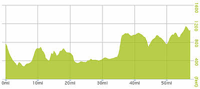
Gradient – Day 31
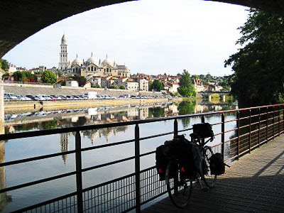
Cathedral of St Front, Peregueux (9:07)
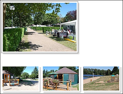
Camping du Lac, St Mathieu (Site Owner)