Day 14 — Wednesday 11 May 2011
Madrigal de la Vera – San Martin del Pimpollar
| Actual Route Details | ||
|---|---|---|
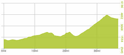
| Riding Distance | 36.86 ml | 59.31 km |
| Uphill Distance | 23.65 ml | 38.07 km |
| Downhill Distance | 9.95 ml | 16.02 km |
| Max Altitude | 4539 ft | 1384 m |
| Altitude Gain | 4711 ft | 1436 m |
| Altitude Loss | 1906 ft | 581 m |
| Alternative Route Details | |
|---|---|
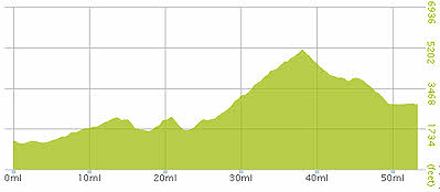
| Riding Distance | 53.37 ml |
| Uphill Distance | 29.11 ml |
| Downhill Distance | 19.80 ml |
| Max Altitude | 5115 ft |
| Altitude Gain | 5548 ft |
| Altitude Loss | 3976 ft |
The original plan was to go to either Casavieja or to Borgohondo both of which are on the routes in Harry Dowdell's book and I have shown an alternative route that I might have taken. But in the end I decided to follow the main road over the Puerto del Pico as it looked less high. On balance I think that was a mistake and given the opportunity again I would have stuck to the original plan.
I set off along the Tietar valley through Candeledar and Arenas, and on to Mombeltron where I had a good lunch. Then came the hard work. I saw the road snaking ahead of me and disappearing up a steep rocky valley cut into the side of the Sierra. For some of the route it wasn't possible to see where the road went. The traffic wasn't heavy and in the steeper sections there were my bêtes noir, crawler lanes, that kept me off to one side but meant that I could see the pain coming. I stopped every Kilometre or so for water and chocolate and when it got too much I got off and pushed. Slowly, slowly I made it. I crossed a remarkably well preserved Roman road that wound itself up the pass beside me. Who said the Romans built straight roads? As soon as I got over the top onto the North side of the Sierra the vegetation became green and there were cows.
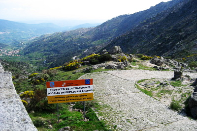
I got to the turn off for San Martin de Pimpollar and down that road I could see that there three campsites marked, but on the junction there was a hostal and restaurant, and the temptation was just too great. I went into the bar and a chap joked that the only Spanish word I really needed was cerveza. The manageress appeared and took me across the road to the hostal, up the stairs to the stone balcony across the front of the building and showed me to a spotless and newly appointed room at the back of the building. She was insistent that my bicycle should not come onto the room with me so I locked it up at the back of the building in a yard that I could see from my window. Beyond the yard was a rocky paddock with some beautiful horses in it. I spent a very comfortable night.

Actual Route – Day 14
Actual Gradient – Day 14

Alternative Route – Day 14
Alternative Gradient – Day 14
Arenas de San Pedro (12:58)
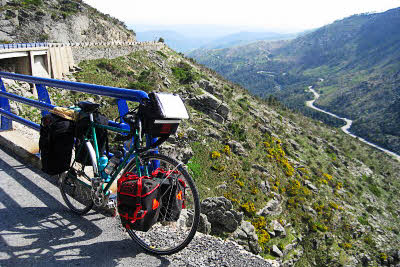
Puerto del Pico—winding zigzags—utterly exhausting (17:34)
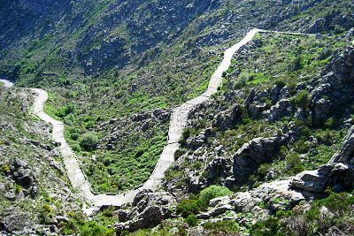
Roman Road at Puerto del Pico (who said the Romans built straight roads?) (17:34)
The Roman Road (17:40)
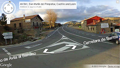
Hostal and Restaurant Opposite N-502/AV-941
(Google Street View)