Day 32 — Wednesday 1 June 2011
St Mathieu – Availles-Limouzine
| Route Details | ||
|---|---|---|
| Riding Distance | 37.66 ml | 60.61 km |
| Uphill Distance | 15.40 ml | 24.78 km |
| Downhill Distance | 17.03 ml | 27.41 km |
| Max Altitude | 1060 ft | 323 m |
| Altitude Gain | 1959 ft | 597 m |
| Altitude Loss | 2628 ft | 801 m |
In one of the text messages from Liz she told me that there were no cross channel ferries from Le Havre. I was pretty sure she was wrong and sent back a request for her to check again, but in the meantime I had worked out an alternative route up the coast to Dieppe.
The night was clear with brilliant stars and consequently it was cold. I was gradually getting into northern Europe and the nights of lying on top of my sleeping bag in Spain seemed a long way off. I set out in weak sunshine into a northerly wind and kept my cycling jacket on most of the day as a windproof. I didn't return to St Mathieu but found my way round the lake to the D675 to Rochechouart with its chateaux sitting high above the road. From there I took the D54 that changes to the D29 across the border from Dordogne to Charante towards Chabanais where I crossed the river.
I had lunch there and lingered for a couple of hours before pressing on along the D59 that cuts across a long bend in the river. I crossed the Vienne again at Manot and rode along the D16 that follows its western bank up to Confolens. From there the D71 continues alongside the river to Availles-Limouzine, passing the ruined chateau of St-Germain-de-Confolens on the other side.
At Availles-Limouzine I crossed to the other side of the Vienne and into a wonderful campsite alongside the river and a public park with a mini-golf course. All was basking in sunshine when I arrived. I paid for the night and went to the end of the site next to a spotless facilities block in which everything worked. I pitched near a couple of Dutch caravans and after a chat I did all my washing, hanging it on a convenient clothes line to the side of the block, and charged my Bryton GPS from my solar panel. I walked back across the bridge and found a bar for a drink and somewhere to write up my diary. Liz sent me a text message to confirm that she had found the boats do sail from Le Havre to Portsmouth and Poole. I didn’t believe that I could have got that wrong when planning how to get back to England. I walked round the old town and down to the riverside opposite the campsite, where there were the remains of old defensive walls and a river gate.
All my washing was dry before I turned in.

Route – Day 32
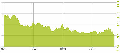
Gradient – Day 32
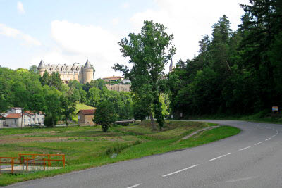
Rochechouart (10:35)
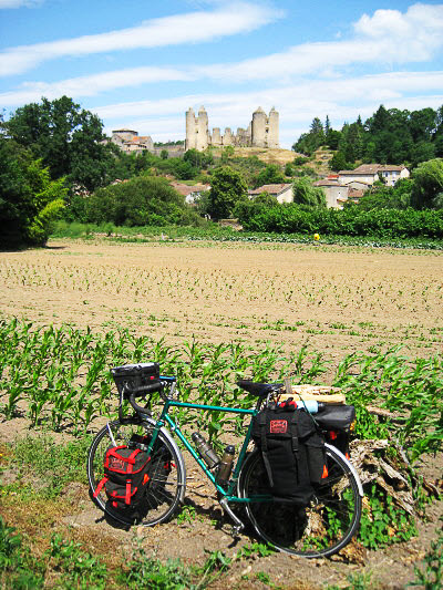
Chateau de Saint-Germain-de-Confolens, from D71 looking across the R. Vienne (15:47)