Day 28 — Friday 27 May 2011
Roquefort – Casteljaloux
| Route Details | ||
|---|---|---|
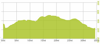
| Riding Distance | 34.49 ml | 55.50 km |
| Uphill Distance | 11.71 ml | 18.85 km |
| Downhill Distance | 8.22 ml | 13.23 km |
| Max Altitude | 522 ft | 159 m |
| Altitude Gain | 243 ft | 74 m |
| Altitude Loss | 348 ft | 106 m |
The day dawned much brighter and I rode back into Roquefort and bought provisions for the day. The route led through quiet forest lanes, pretty much dead flat apart from the occasional small river valley, with dappled sunlight coming through the trees. This is what cycling is all about. There was no difficulty with map reading although some of the roads were so small they did not appear on my Bryton GPS Open Source maps. It's funny that the abbreviation “OS” could stand for Open Source as well as Ordnance Survey.
The first village on the route was St-Gor, where a beckoning siren of a café/bar dragged me in by the hair roots for a welcome coffee and a croissant. I sat outside on the terrace soaking up the sun. Opposite the bar was a tree decorated with paper flowers (why?) and across the road was an amphitheater. I have found a number of these in southern France, one of the most notable being the Roman arena in Arles, on the River Rhône. Like many others Les Arènes de St-Gor is a wooden construction that a year earlier, when Google Street View recorded it, had no surrounding fence. Wikipedia makes reference to these arenas being used for bullfighting and the one at St-Gor (at least when I saw it) had narrow refuges around the inside of the arena that could be for a person to hide in, so I suppose that is what they are: French bull rings.
I passed a couple cycling sedately along on their sit up and beg bicycles and waved a cheery bon jour but got little response. Later I came to a restaurant at a cross roads in the forest and stopped for menu du jour. The couple caught me up and also came into the restaurant, the wife nudged her husband and pointed at me with a smile, so we had a chat about where I'd come from. I like to think they were impressed, but maybe they just thought I was a bit mad. Le Patron looked like a Hell's Angel, built like a tank with tattoos up his arms, head shaved and a small goatee beard, but his food was excellent, and an hour later I pedalled on through Losse and Allons, rejoining the main D933 just south of Casteljaloux.
I came into the town from the south passing a campervan pump out station and overnight stop, but with no other facilities. I stopped and scratched my head, and at that moment an elderly man on a dilapidated bicycle rode over to me and promptly fell off. I leapt off my own bicycle and helped him to his feet. He showed me the way to the municipal campsite, repeatedly gesturing that it was à gauche by the river. I found a delightful site bathed in sunshine a stone's throw from la centre ville. Everything worked and there were a number of caravans there but no tents. After cleaning myself up and putting my washing out to drip dry in the sun I walked into the centre and found a pâtisserie that heated up a croque monsieur and a quiche lorraine for me. I sat in a quiet park on a bench soaking up the evening sun eating my supper.

Route – Day 28
Gradient – Day 28
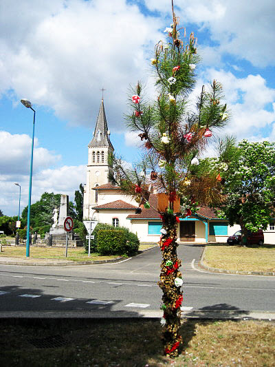
St-Gor, paper flowers but the tree is real (10:53)
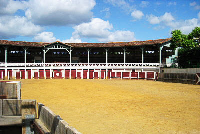
Les Arènes de St-Gor (10:54)
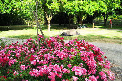
Casteljaloux campsite (19:12)