Day 39 — Wednesday 8 June 2011
Maintenon – Anet
| Route Details | ||
|---|---|---|
| Riding Distance | 27.34 ml | 44.01 km |
| Uphill Distance | 8.26 ml | 13.29 km |
| Downhill Distance | 12.49 ml | 20.10 km |
| Max Altitude | 373 ft | 114 m |
| Altitude Gain | 509 ft | 155 m |
| Altitude Loss | 653 ft | 199 m |
I’d picked up a €5 note in the bar the previous evening and given it to Madame. As no-one had claimed it she gave me a free breakfast. I set off along the east bank of the Eure to Anet with it’s delightful chateau. The roads were small and wooded by the side of the river, passing through small suburban villages interspersed with delightful parkland. In the villages there were frequent road works leaving the surface pitted with trenches, badly filled pot-holes and frequent street metal-work that was placed at exactly the wrong place for a bicycle. I puffed up to Guainville where there was supposed to be a well documented campsite. It even had a website, but no-one knew where it was. I found a caravan park but they did not take tents so I gave up faffing around and went back to the municipal site at Anet.
I wore my fleece for most of the morning despite the sunshine, an indication that I was getting further north, but at least it did not rain. I asked at the campsite office and got confirmation that there was a site at Louviers where I was heading next. I left my washing hanging between two trees as it was not dry by the time I went to bed, but at one o’clock I heard spots on my tent and ran over to the clothes line just in time to prevent it getting drenched. I don’t think I’ve ever got out of a sleeping bag so quickly.

Route – Day 39
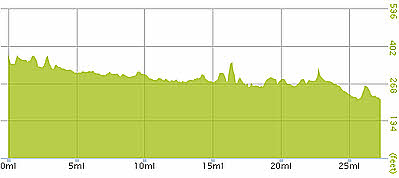
Gradient – Day 39
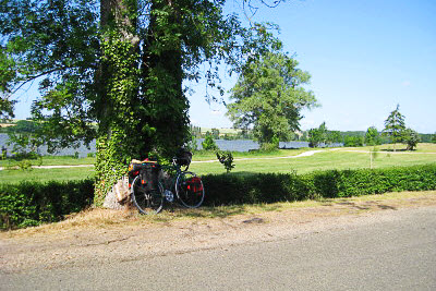
Small lanes along the R Eure (10:26)