Day 22 — Friday 20 May 2011
Arnedo – Olite
| Route Details | ||
|---|---|---|
| Riding Distance | 37.71 ml | 60.68 km |
| Uphill Distance | 15.31 ml | 24.64 km |
| Downhill Distance | 14.08 ml | 22.66 km |
| Max Altitude | 1719 ft | 524 m |
| Altitude Gain | 974 ft | 297 m |
| Altitude Loss | 1398 ft | 426 m |
I had an enormous breakfast making the best of the inclusive price. The road out of Arnedo went East along the mature river valley past market gardens and villages with quiet parks in one of which I stopped for a banana. I was cycling with high sandstone cliffs on my left and the wide river valley on my right. In the cliffs there appeared to be rock houses high above the road. Out of Autol the road climbs steadily up and over a ridge into the valley of the Rio Ebro, down a long eight kilometre straight stretch to the Canal de Lodosa and across a motorway and a railway line making use of the wide valley. I threaded my way through Aldeanueva and Rincon and then the road turned North changing its designation from LR to NA as I was now in Navarre. I climbed up and out of the Rio Ebro valley and into the valley of its tributary the Rio Aragon. I stopped to take a photograph looking down on Peralta where eventually I found lunch. Crossing these huge valleys was remarkable. They were full of small towns and lots of agriculture, with more people than I had come across in much of the journey so far.
In Peralta I stopped at a bar that had a sign for a restaurant, but it was not operating and the people in the bar pointed out a restaurant back down the way I had come. I set off in the wrong direction and they all shouted at me from across the street. I turned round and waved at them, finding the restaurant in the first floor of a large office block behind a line of trees. Lunch was good and when I came out someone had left a two litre bottle of water tucked under a bungee on my rear panniers. I spotted a sign in a shop giving the temperature as thirty degrees centigrade.
The final stretch was steadily uphill alongside an autopista and then a right turn down to Olite. There is a camp site at Olite, and I found it, but not without riding right through the town to an industrial estate and then doubling back onto the road I was on before turning off for Olite. The site is on the NA-115 and could easily be signed from the Northern approach as well as the Southern. Although I had to ride round in a cicle I was pretty relieved when I finally found it. It was a big site with lots of static caravans and chalets with neat little picket fence gardens and a blasted heath at its far side for tents, with electric hook up points laid out in a grid. The ground was rock hard with bare patches between the grass. On one of my first camp sites I’d found a small stone that fitted into the palm of my hand and had an indentation on one side that made a great peg hammer. Gentle tapping drove pegs in without bending them. I’ve still got the stone.
When I arrived there was no-one else camping and very few in the chalets, so I washed and hung my cycling kit over an unoccupied chalet’s fence to dry in the evening sun. I went up to the campsite bar that people seem to treat as their local and a wise gut had all my maps out on the floor to see where I had been. They asked me if I was going to Santiago and were surprised that I wasn’t. This is the first time I’ve been asked, and it happened a number of times over the next few days.
Before I turned in I spotted another cyclist pitching about a hundred yards away. In the morning we would meet and have breakfast together, but that night I just wanted to get my head down.

Route – Day 22
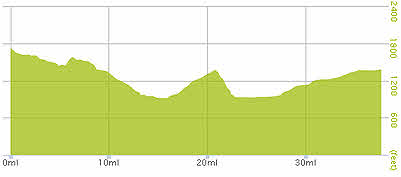
Gradient – Day 22
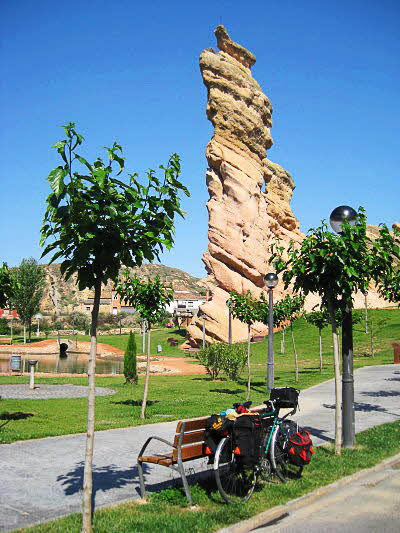
Public park at Autol (10:55)
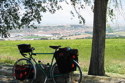
About to freewheel down to Peralta for lunch (12:43)
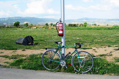
Deserted campsite at Olite (18:18)