Day 25 — Tuesday 24 May 2011
Isaba – Aramits (France)
| Route Details | ||
|---|---|---|
| Riding Distance | 34.67 ml | 55.80 km |
| Uphill Distance | 14.94 ml | 24.05 km |
| Downhill Distance | 16.82 ml | 27.07 km |
| Max Altitude | 5812 ft | 1771 m |
| Altitude Gain | 3271 ft | 997 m |
| Altitude Loss | 5010 ft | 1527 m |
This was the big day! I had chosen out of sheer devilment to go over a high pass. I calibrated the altitude carefully on my Bryton50 GPS device and if it had not been stolen on my last day in France the trace would have been fascinating. As it is I have to rely on the plan I drew later on Bryton's website. Isaba is at exactly 800 metres (2626 feet) and the Col de la Pierre St Martin is at 1,760 metres (5776 feet) according to the contours on Google Maps and the Michelin map, although the sign at the top of the pass declares 1,802 metres. Aramits is at 280 metres (919 feet), so if I take the sign at the top as being somewhat aspirational and the map to be more accurate then the total climb for the day was at least 960 metres (3151 feet) and the total descent at least 1480 metres (4857 feet).
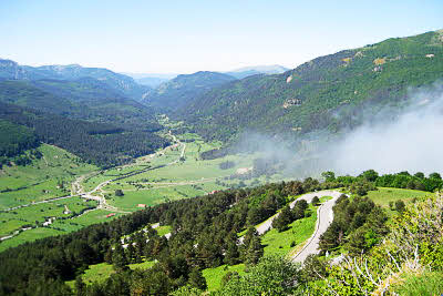
About five kilometres North of Isaba I came to Camping Isolaze (Isolated) and kicked my self for not being sufficiently inquisitive. Anyway it was too late by that stage so I drew a deep breath and carried on. At the head of the valley it opens out into a sort of Alpine basin with pastures separated by wooden fences. Barns dot the landscape and the road circles round the basin anti-clockwise and is completely level. I came across another campsite and holiday trekking centre. I have been following it again on Google Street Maps but just at the point when the road curves round the back of the basin to start its climb Google came across Spanish road works and the road was Cortada por Obras (closed for works). I'm glad that on my day the works were no longer there.
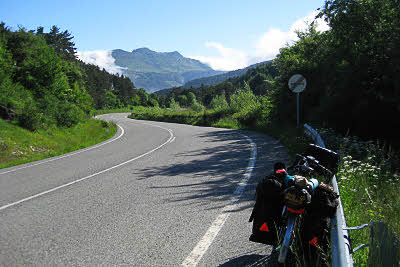
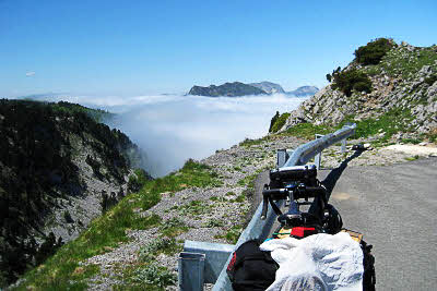
There was cloud streaming over the top from France and pouring down the southern Spanish side in a great river that evaporated before it got to the basin floor. I could see from the GPS map that there were seven hairpins up the mountainside and watching my moving position gave a positive sense of progress. I managed to stay in the saddle all the way up, although I did stop for photographs, water and nuts from time to time. At the top of the main ascent the road flattens somewhat although it keeps going up and I rose into the bottom of the cloud. It was cold and wet so I put on my waterproof. The road runs along the national boundary for three of four kilometres before dipping back into Spain and then climbs up between high rocky walls until it comes to a corkscrew where it doubles back and crosses a bridge over itself.
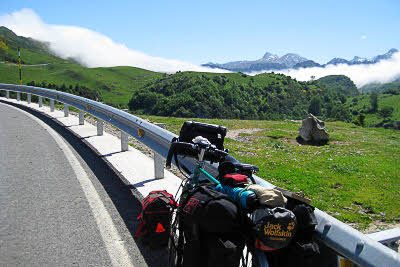
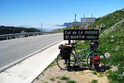
More rocky wall climbing brought me back into sunshine above the cloud and I came to a viewing lay-by occupied by a group of motor bikers who turned out to be from Cardiff. On I went. Now there were snow poles on the side of the road and suddenly a road sign in French announcing that Ici, Les Pyrênêes Sont Atlantique. I was no longer on the NA-1370, but the D-132 and in France! I rode back and found the sign for the Col de la Pierre St Martin that I had missed, and took a photograph.
Half a kilometre further on the road surface deteriorated and started writhing downhill at a rate of knots. Back into the cloud, wet and cold, waterproof jacket, ugh! My spectacles had steamed up so I was cycling blind using my GPS map to anticipate where the next sharp bend was. It was the only time on the whole trip I had to hang onto my brakes for dear life. The North side of the Pyrenees was in cloud and as I dropped underneath it was cold and damp so I kept my jacket on.
I was only half way but it was all downhill from there. I started looking for somewhere for lunch. In Spain it is difficult to get lunch much before half past one but in France midday eating is two hours earlier, from eleven thirty to one thirty at the latest. Why? They are on the same longitude, it doesn't make sense! No restaurants appeared until I got to Arette but then it was a quarter to two and Madame could not provide a Menu du Jour but she did offer a baguette which I gratefully accepted along with a strong black coffee.
After that it was only about four kilometres to Aramits and as I got close up popped a most welcome camping sign. French camping sites are generally well posted and much easier to find than Spanish ones so within five minutes I was there. Which is more than could be said for anyone else, so I decided just to pitch where I felt like. By the time someone turned up at the site office I had washed and showered and my kit was hanging on a laurel hedge making a vain attempt to dry in the overcast conditions.
I went off for a walk and found a Supermarché. Wow! What a difference from Spain. A veritable cornucopia of basic foods, luxuries, general kitchen and household wares that was a real treat. Road surfaces are generally not a patch on Spanish ones but the French eat better. I stocked up and went back to the campsite for a really good supper.

Route – Day 25
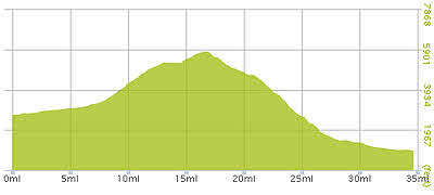
Gradient – Day 25

Zig-zags with a vengeance

The road actually does a corkscrew
Cloud flowing over the Pyrenees (10:13)
Half way up, view back down the Val del Roncal (11:40)
Cloud streaming over from France (11:47)
Above the cloud, handkerchief drying! (13:03)
Wow! The top of the world (13:12)