Day 27 — Thursday 26 May 2011
Orthez – Roquefort
| Route Details | ||
|---|---|---|
| Riding Distance | 53.43 ml | 85.99 km |
| Uphill Distance | 17.52 ml | 28.19 km |
| Downhill Distance | 16.74 ml | 26.94 km |
| Max Altitude | 440 ft | 134 m |
| Altitude Gain | 1444 ft | 440 m |
| Altitude Loss | 1404 ft | 428 m |
Today did not go as well as some. It had rained in the night and I didn’t take my little bicycle mileometer off the handlebars so it got wet. The display faded to nothing although I could just make out the large speed numerals registering. It was no good using it to record distance, time etc. as those small numbers on the display were unreadable. At one point during the day I came to a large hyper-market and bought a new battery but that made no difference. Instead I relied on the GPS unit. I rode back to the cross roads where I’d had a drink the night before but couldn’t find the junction on my Michelin road map; the map scale was too big to show sufficient detail. The Bryton GPS unit showed precisely where I was but only on its tiny screen, so I scrolled the display round until I spotted a major road number that checked with the Michelin map, and then followed the GPS unit out of town until I could see on the map which road I was on. I would not have been able to get out of Orthez as easily with the map alone.
I rode up the D933 along undulating roads and just after Sault de Navailles crossed the border between Les Pyrénées Atlantiques and Les Landes. I found lunch at a pleasant restaurant in Hagatmau where the central streets were lined with green traffic calming balls. The transition from mountains to flat land was not dramatic, as the road from Orthez was straight and rolling, but approaching and crossing the River Adour at St Sever everything definitely flattened out. Just before St Sever the D933 became a dual carriageway so I took a quieter road into the town and on to Mont de Marsan along quiet roads running alongside.
I got lost trying to get through Mont de Marsan and had to double back to get my bearings. This was frustrating as I thought I could see a clear route through the town, but sign posts were confusing and it took some time to get on the right minor road away from the main road towards Roquefort. Michelin shows a motorway under construction and I wanted to avoid that in favour of the lanes now running through an area shown as Parc Naturel Regional des Landes de Gascogne. These turned out to be narrow, straight, flat, quiet and surrounded by intermittent fields and pine woods; altogether delightful cycling though the weather was so cool and overcast that I took no photographs.
I turned East on the D626 to get back to Roquefort. I can’t remember how, but I picked up campsite signs to a municipal site at Sarbazan. In hindsight there appears to be a better municipal site closer to the centre of Roquefort. The one at Sarbazan was bleak and the facilities barely functioned. The site was managed by a chap living in a chalet surrounded by a wooden deck who appeared to be surprised to have anyone visiting the site. There were no other campers apart from a friendly young man from Senegal called Gibraelle who came over for a chat.

Route – Day 27
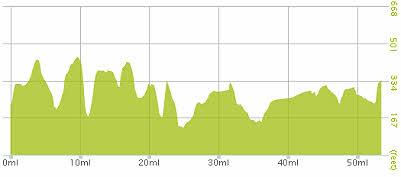
Gradient – Day 27
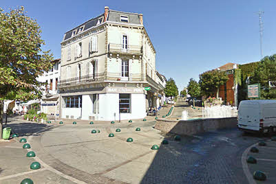
Hagetmau with its green traffic calming balls
(Google Street View)