Day 2 – Monday 9 July 2012
Oberstdorf – Leutkirch-Herlatzhofen
| Detail | Imperial | Metric |
|---|---|---|
| Riding Distance | 38.9 ml | 62.61 km |
| Start Elevation | 2591 ft | 790 m |
| Total Ascent | 1444 ft | 440 m |
| Max Elevation | 3101 ft | 945 m |
Campsite
Camping Moorbad, Inh Fam Riedle, Moorbad 2, 88299 Leutkirch-Herlatzhofen
https://campingmoorbad.de/
Notes
During the night there was a thunder storm, but but by the time we got up at seven o'clock it had cleared up. We had boiled eggs, yoghurt, rolls, cheese and an orange for breakfast before setting off at about ten o'clock. The first third was a steady downhill gradient down the valley as far as Immendstadt, but then I had a bit of a pull up the ridge behind the Alpsee after which there was a steady run down all the way to the campsite, much of it in top gear. The valley opened out into a wide flat plain. There was both arable farming and cattle with alpine bells round their necks.
I came across my first German cycle path, avoiding the main road past Isny, and deviated from my planned route to take the path. I zoomed out my Bryton50 GPS device so I could see my saved route off to one side of the screen, just to make sure that I didn't lose track of the end of day route to the campsite. In 2011 I had planned my daily routes by conventional map and created a detailed daily turn list, but without specific information about where the campsites were. I had taken it on trust that where the mappers had noted a campsite there would be one, and that where none was noted there wasn't one. Well, how silly can one be? This time I had found each campsite on the http://en.camping.info/ website and plotted the route to it on my GPS device. While Liz was with me I also saved each campsite on our car's GPS device so that there would be no difficulty in her getting there as well, which was kind of important as she had all the kit!
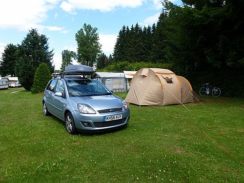
There are two campsites on the Moorbad lake south of Herlazhofen. I had booked us in at the Campingplatz Moorbad Riedle. With my GPS I went straight there, wiggling around lanes and down through a farmyard where they were building a new barn. I was amazed by the high quality of the construction, substantial wooden beams and giving the impression of attention to detail. I contrasted it with what I have seen of English farms south of Birmingham where I regularly cycle and where there appears to be so much dilapidation. No doubt it is something to do with the financial structure of the farming economy in different countries.
I found Liz pitched on a field reserved for tents above the rest of the site that was largely given over to static caravans each with their own little gardens, leading downhill to the side of the lake. I went down to the facilities block for a shower and to wash my kit, but the Putzfrau was doing her thing, and rather than endure the tongue lashing I had in Oberstdorf I just smiled and turned to leave her to it, but she called me back and opened one of the shower coin boxes so I could use it for free.
In the evening Liz and I went for a short walk round the site. Hardly anyone was in residence. We turned in after a successful first day.
This first day's route I took was much the same as the one in Torfmann's book. His route has nightly accommodation stops and mine has campsites all the way, so as the journey progresses there is increasing digression, but all roads lead to Sylt … eventually.
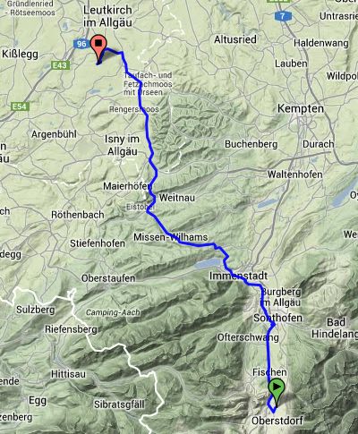
Route – Day 02
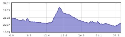
Gradient – Day 02
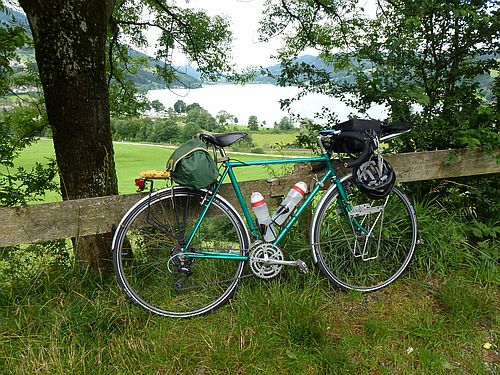
Grosser Alpsee, NW of Immenstadt: 9/7/12 (11:22)
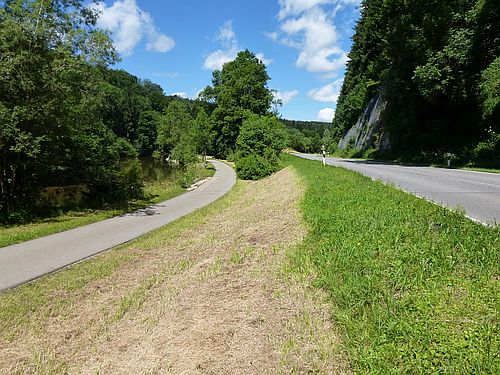
My first experience of a German cycle path: 9/7/12 (12:31)
Camping Moorbad: 9/7/12 (14:38)