Day 1 – Sunday 8 July 2012
Oberstdorf – To the end of the road and back!
| Detail | Imperial | Metric |
|---|---|---|
| Riding Distance | 13.26 ml | 21.33 km |
| Start Elevation | 2595 ft | 791 m |
| Total Ascent | 2333 ft | 711 m |
| Max Elevation | 4334 ft | 1321 m |
Campsite
Campingplatz Oberstdorf, Rubinger Strasse 16, 87561 Oberstdorf
www.camping-oberstdorf.de/
Notes
This is the data for the ride to the end of the road. Of course I had to ride back again, but it was down hill all the way.
On the previous day (Saturday) Liz and I had driven from Nenzing to Dornbirn, and then followed a minor road marked as “scenic” by our Michelin road atlas, via Lingenau and Balderschwang where we had lunch, and thence to Fischen and Oberstdorf.
The campsite was like nearly all German sites: neat and tidy with a spotless services block, electricity (Strom) from a distribution box that had to be unlocked by the site manager, and a formidable cleaning lady Putzfrau who was not to be argued with when it came to where I should wash my sweaty cycling kit. We pitched near the edge of the site next to a single track railway line along which an occasional train rumbled past on its way to the end of the line in the centre of Oberstdorf. Regular enough to set your watch by, but no more of a disturbance than that.
The weather was warm and sunny with occasional cotton-wool clouds, except for half an hour when a mountain storm with high winds came out of nowhere and threatened to blow everything away. I set off for the first day’s ride towards the southern tip of Germany. There was no problem with route finding, I didn’t really need a map, let alone my GPS device, as there’s only one road! I passed walkers and other cyclists as well as a number of people using walking-frames on a supported event. I was impressed at their courage and efforts.
It got steep, and I was grateful of my 28 – 34 gearing that I tried out for the first time. In Spain during my 2011 ride my lowest gear had been 28 – 28 and I had to get off and walk on occasions.
Working out gear ratios appears a bit baffling. The English way of doing it is to take the ratio of the rear sprocket to the chain ring and multiply that by the wheel diameter. So that my lowest gear on my old set-up would be 28 / 28 * 27, which gives a gear ratio of 27 inches. This is a bit meaningless other than to give a comparison with other gears. My highest gear would be 48 / 14 * 27 = 92.6 inches. This tells me that my lowest gear is somewhere between three and four times lower than my highest one (29%). It seems to me that the continental method is more intuitive. It uses the circumference of the wheel rather than the diameter, which then gives the actual distance travelled in one revolution of the peddles. On that basis my lowest gear was one that pushed me along just over seven feet for each pedal revolution. With my new rear block and a 34 “granny” ring my new lowest gear pushed me along a mere five feet nine inches. My highest gear remained the same at approximately 24¼ feet long per pedal revolution.
I got to a really steep bit so dropped into the lowest gear and immediately started to pedal like a fury. I didn’t last long and stopped in a muck sweat. Having stopped I encountered the problem of starting up again. With such a low gear it’s almost impossible to get up enough speed to balance the bike. The secret is not to stop, but slow down and pedal steadily even though the bike is moving very slowly.
The gradient levelled out and I passed the sign for the Mindelheimer Hutte that is pictured in Hendrik Torfmann's book. About half an hour later I got to the end of the road, where the metalled surface ended and a gate had a sign announcing Privatweg. A walker came through and continued towards the head of the valley. There was a farm where a number of people were corralling bullocks and putting them into cage where they appeared to be gelded. On release the bullocks skipped off to join their mates, apparently none the worse for wear. There was a chap who had passed me earlier on his bike as I took a break. We got into a broken conversation. He told me he was 70 years old and we commiserated with each other on our mature years.
After taking photographs I set off, speeding downhill all the way to Oberstdorf.
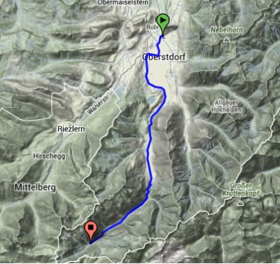
Route – Day 01
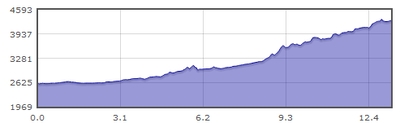
Gradient – Day 01
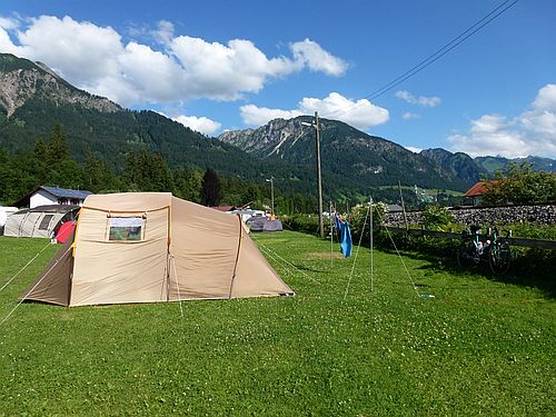
Campingplatz Oberstdorf: 7/7/12 (16:25)
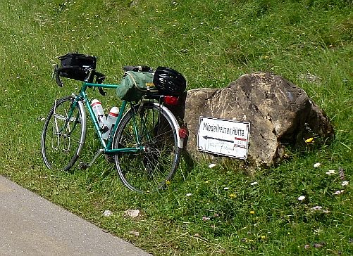
Sign for Mindelheimer Hutte: 8/7/12 (10:27)
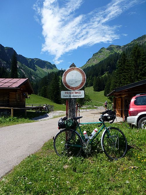
Oberstdorf, Road’s End: 8/7/12 (11:08)