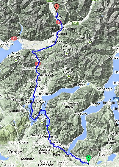
Day 1 – Monday 28 July
Montofarno to Claro
| Route Statistics | ml / ft | km / m |
|---|---|---|
| Riding Distance | 60.31 | 97.06 |
| Total Ascent | 4544 | 1385 |
| Total Descent | 4829 | 1472 |
| Start Elevation | 1201 | 366 |
| End Elevation | 915 | 279 |
| Min Elevation | 650 | 198 |
| Max Elevation | 1837 | 560 |
Intended Campsite
Campeggio Al Censo (http://www.alcenso.ch/)
Actual Hotel
Hotel Morobbia, Giubiasco (http://www.hotelmorobbia.ch/)
Notes
I started out in high spirits from Montofarno at nine o'clock and an hour later I was in Como. I crossed out of Italy into Switzerland with hardly a glance from the border guards. My impression of Como was much the same as Nice, a built up suburban landscape full of high rise offices etc. Once over the border into Switzerland the roads became much smoother with the cracks actually filled in and all roads had a cycle lane to the side that cars actually respected.
I found a pot of tea and a sandwich at a roadside café and later I found a somewhat expensive pizzeria in Lugarno for lunch and chatted to the proprietor about my ride. He and his family were eating their own lunch and they me wished good luck. I was stuck on main roads so I was not following my satnav, relying on the map. At one point the road signs that had been pointing to Taverne and Bironico stopped showing them and merely pointed to Bellinzona. I tried to follow but found myself heading for a motorway and got shouted at by passing motorists. With a bit of head scratching and checking with a passing pedestrian I managed to find the right road and got as far as Taverne when I heard thunder behind me. I checked the wind direction and the state of the clouds and thought there was a chance that it might blow by to the west, but shortly afterwards the rain started. I pulled into a garage in a busy suburb and put on my waterproof gear and set off again.
The thunderstorm became relentless and I rode in the rain for about an hour with no indication that it was going to ease. I gave up the small road that the cycle route follows and turned onto the main road (A2) and promptly got soaked from the spray of passing cars and lorries. At Giubiasco I passed a hotel and turned off to shelter under its front balcony. I hardly gave it a second thought but walked dripping into the hotel lobby and booked in for the night. Claro was only about 10 miles further on but the thought of pitching my tent in the pouring rain was really rather unattractive. I have left the route statistics the same. The distance is the only real change, from 60 to 50, but the height numbers are not significantly altered. Giubiasco to Claro is pretty much level riding.
I washed everything in my hotel room including my towel and sleeping bag liner and the water turned black! It was all dry by the morning, which you could not say for the weather. In Italy beds were covered by a top sheet and a counterpain but in Switzerland a duvet had reappeared.
On Tuesday the morning cloud was down at ground level. The forecast was for wet conditions for 48 hours so after a good breakfast I set off for the railway station a kilometer away. There was no security barrier in the ticket office and a lady at a desk sold me a bicycle pass and a through ticket to Basel. My platform was on the other side of the tracks but there were ramps to all platforms and I simply rode through an underpass and up the other side. When I arrived the platform was empty but about two minutes before the train was due people appeared and within 30 seconds of the due time the train rolled in and stopped with a bicycle symbol on the door in front of me. At Belinzona I had to change trains but didn't have to change platforms. Five minutes after my first train left, my second train rolled in. On I got and secured my bicycle with a bungy strap to a grab handle at the end of the carriage. The ticket inspector hardly gave my bicycle a glance and by five o'clock I was in Basel.
The train journey was enjoyable, through intimidating gorges with roads sometimes below and sometimes above teetering at impossible angles on viaducts arching from tunnel to tunnel. In these conditions cycling would have been very tricky and thoroughly uncomfortable so I'm glad I decided not to do it. Nevertheless I felt pretty deflated.
In Basel there were lifts from the platforms to an overhead concourse and down to the street. I switched my satnav and wound my through the town for about four kilometers to a footbridge over the Rhine into France. The campsite at Huningue was pleasantly disorganised, mainly tents and cyclists all pitched haphazardly on a grassy space with no regimented plots. The manager was very French and corrected my pronunciation.
Day 13 – 60 Miles
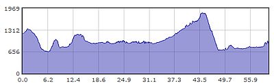
Gradient – Day 13
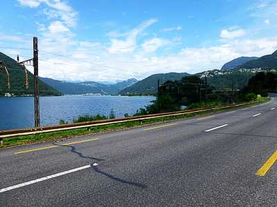
My first view of Lake Lugarno near Riva S Vitale (11:54)
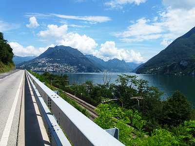
Approaching Lugarno (12:46)
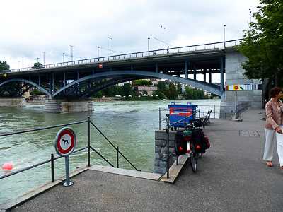
The Rhine, Basel (14:51)
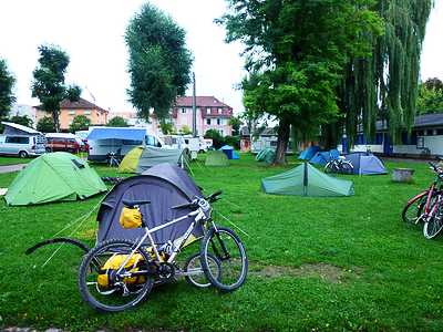
Camping Au Petit Port, Huningue (Tuesday 06:53)