Day 2 – Thursday 31 July
Thann to Charmes
| Route Statistics | ml / ft | km / m |
|---|---|---|
| Riding Distance | 71.75 | 115.47 |
| Total Ascent | 5245 | 1599 |
| Total Descent | 5494 | 1675 |
| Start Elevation | 1112 | 339 |
| End Elevation | 863 | 263 |
| Min Elevation | 827 | 252 |
| Max Elevation | 2520 | 768 |
Campsite
Camping les Iles (http://camping-les-iles.chez-alice.fr/)
Notes
Thursday dawned bright and sunny. Why couldn’t we have had this weather yesterday? I set off up the main road over the Col du Bussang. There was a Michelin green route a little further south but it looked impressively hilly with some tortuous haripin bends so I stuck to the main road that had a few of its own but not as steep. I was able to keep going steadily in my penultimate low gear and half way up came to a café where I stopped to cool off in the shade with a coca-cola and a huge baguette sandwich that they made for me. I ate half of it there and saved the rest for lunch later on.
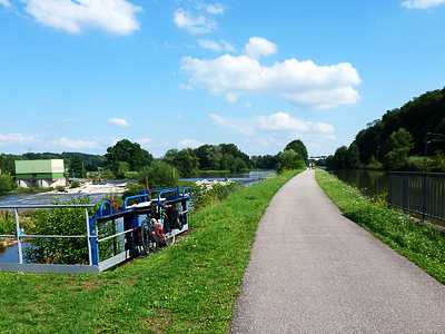
Just over the col I came across a signpost to the Source de la Moselle. It was a there and back ride of a couple of kilometers so I didn’t venture to see it. At Bussang I saw the campsite that I should have stopped at last night and felt a bit guilty. I was looking out for the Moselle cycle path that starts at Bussang but I didn’t come across it until St Maurice sur Moselle, a couple of kilometers later. I stopped and turned back to the signpost that lead me through a car park and down to the path that is built on a disused railway track following the river downhill all the way to Remiremont. It has calming gates all along its length so you can’t just let rip, but for the most part I was in top gear. It was the sort of riding I hadn’t had since leaving the Rhône weeks before. As I was checking my map a chap asked if I needed some help and I asked him if I was on the right way to Charmes, my next camp site. He was adamant that the cycle path went all the way. Well, that wasn’t quite right. From Remiremont I had to follow roads running alongside the river and a motorway to Epinal. But from there the Canal de l’Est does go all the way to Charmes with a fantastic cycle path alongside, as flat as a pancake. All in all that was one of the best day’s cycling of the whole expedition.
The campsite was a dream. It was quaint with a funny little café area where a chap in an open sided caravan made snacks to order on a rotisserie, a couple of microwaves and a toaster. There were bottles of beer from the camp office and continual banter between the ladies in the office and the chap cooking. The whole site was grassed and there was a healthy mixture of caravans, motorhomes and tents with no permanent chalets that I could see. As I was waiting for my snack of meatballs and chips a Dutch cyclist sat down by me and we chatted away for an hour. He was regretting the privatisation of Dutch social services and before we turned in we’d put the world to rights. There was also a family of Belgium cyclist heading for Les Trois Maries de la Mare. They were amazed that I had been there some weeks before. The father was dragging his reluctant daughters across France with the carrot of a week by the sea. Persuasive or what?
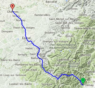
Day 2 – 72 Miles
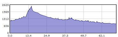
Gradient – Day 2
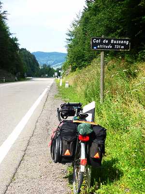
Col du Bussang (10:46)
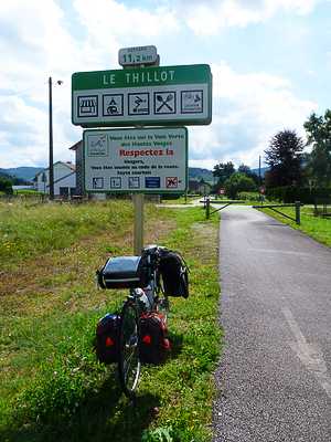
Moselle Cycle Path, Le Thillot (11:36)
Canal de l’Est, Charmes (16:25)