The Whole Route
The idea of cycling to Rome began to grow during the autumn of 2013 and became a strong possibility when my local CTC group suggested a tour from Calais down the Rhône cycle path to the Mediterranean. That became my spring board for the first section of the adventure. The route down to Sète followed much the same line as that completed by two members of the cycling group that I forced myself upon shortly after my retirement. Rob and Jon had ridden from Calais to Pontpellier in 2008 and had written of their experiences in their book Wine-ding Down Through France that they published that same year (I have a copy!). The remainder of the route is my sole responsibility and was dictated somewhat by Liz’s determination not to be left out completely. After occasional discussions during the autumn and winter months of 2013 we decided that we would meet up in Rome for a long weekend’s site seeing. That meant that I had to get there on time and in the event I had to take emergency steps to keep the date.
I had never ridden in Italy before, but as a Christmas present I received Lonely Planet’s Cycling Italy guidebook by Ellee Thalheimer. She gives a lot of good advice, especially about locking up your bike securely, not forgetting to secure both wheels to the frame. Part of her routes fitted into where I was going so they formed part of the planning process, but the main guiding influences were the location of camp sites. I used the Camping.Info website almost exclusively to locate them and then either plotaroute.com or bikehike.co.uk to measure distances and plot out routes. On those websites it is possible to use Open Street Mapping rather than the ubiquitous Google Maps. Working on the basis of between 50 and 70 miles per day I slowly stitched to adventure together.
As I became satisfied with each day’s route I downloaded the .gpx files from the websites and then uploaded them to my Bryton50 satnav device. Additionally I traced the route in pencil onto my Michelin 1:200,000 maps. When cycling often I would switch off the satnav and rely on the maps. You have a wide view of the terrain from a map that is impossible from a satnav and it is somehow more satisfying to find one’s way by map alone. Maybe that comes from my dimly remembered days as a Boy Scout.
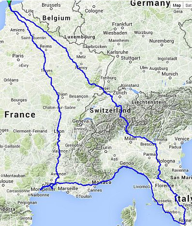
Whole Route: 2,621 miles